
Journal Papers
Telehealth Infrastructure for Cancer Care in the United States
Scientific Data, 2026
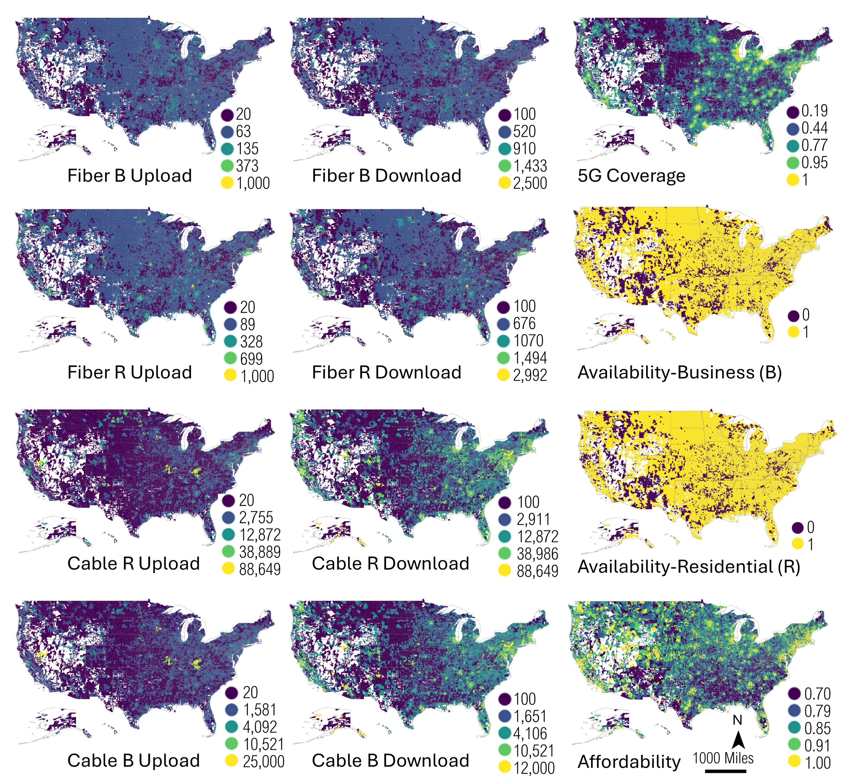
Telehealth can reduce travel barriers to oncology, yet its impact depends on both digital connectivity and the geography of care. This paper presents an open, reusable dataset describing telehealth infrastructure at the ZIP Code Tabulation Area level across the United States, integrating oncologist accessibility, broadband and 5G availability, internet affordability proxy indicators, and national road travel-time matrices. Based on these inputs, the study computes in-person accessibility by 2SFCA and telehealth-enabled accessibility by 2SVCA under multiple travel-time thresholds and releases source, intermediate, and final indicators together with a replicable workflow for transparent reuse.
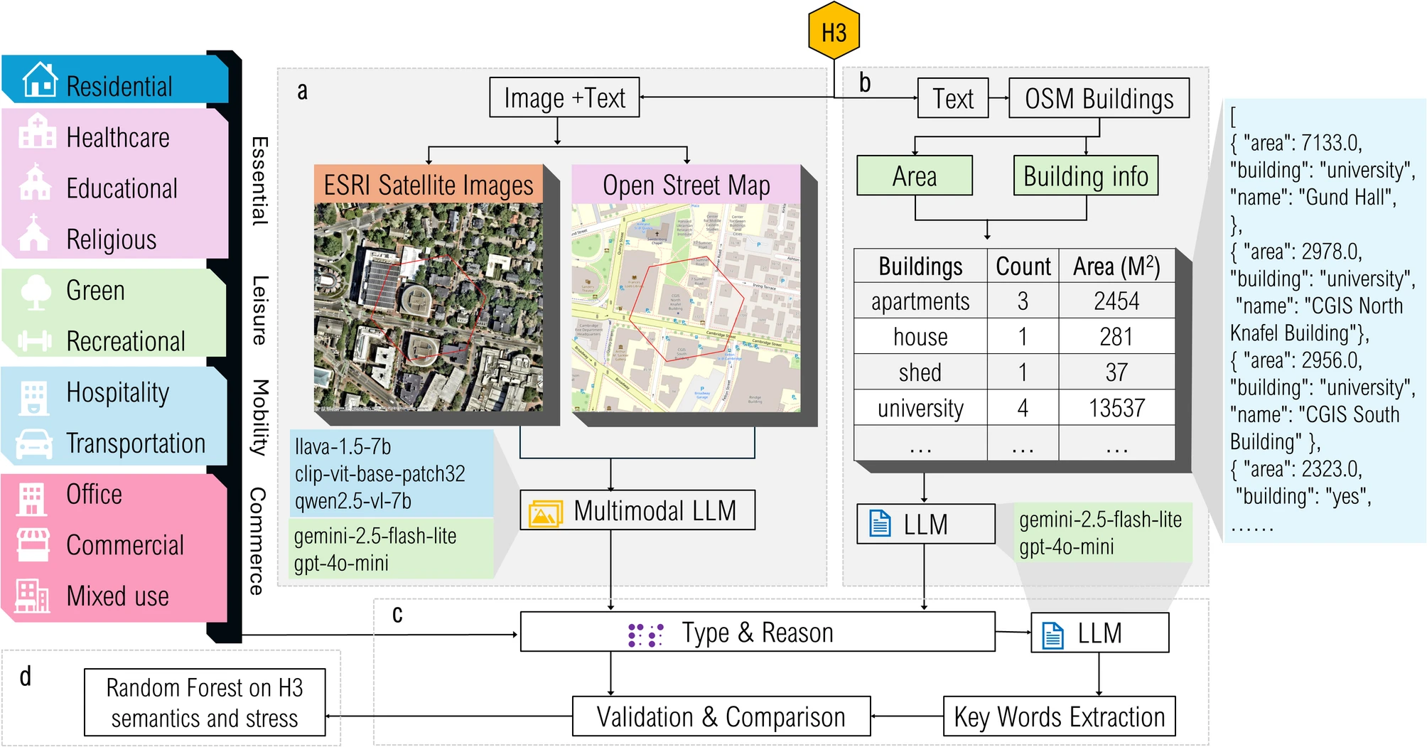
H3-MOSAIC: Multimodal Generative AI for Semantic Place Detection from High-Frequency GPS on H3 Grids in Mental Health Geomatics
International Journal of Health Geographics, 2025
This study introduces H3-MOSAIC, a multimodal generative AI framework that fuses OpenStreetMap building text and satellite imagery on H3 grids to infer semantic place types from high-frequency GPS trajectories. The workflow denoises minute-level GPS, maps records to H3 hexagons, and compares text-only, image-only, and fused multimodal classification across open-source and proprietary models. Results show multimodal methods significantly improve semantic classification accuracy and consistency, supporting more robust downstream mental-health exposure indicators such as homestay, location entropy, and activity-space characterization.
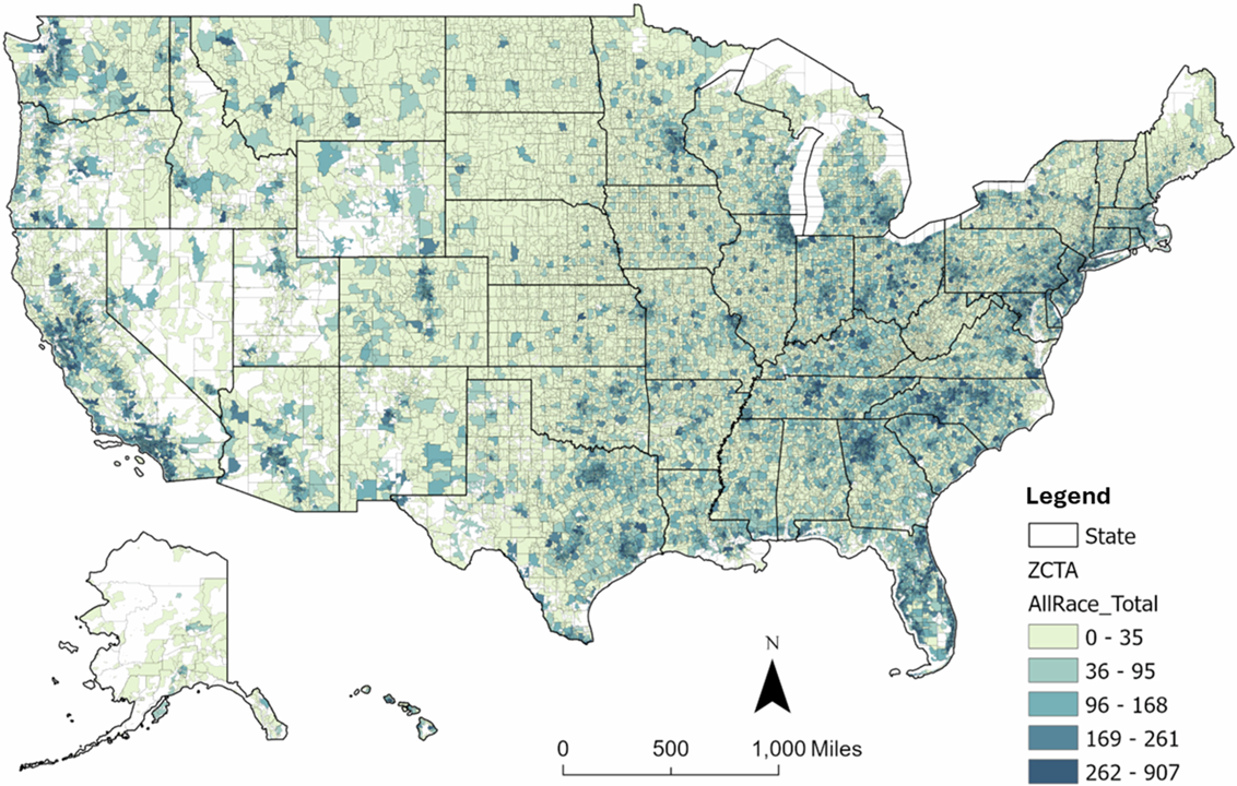
Digital divides in telehealth accessibility for cancer care in the United States
npj Digital Medicine, 2025
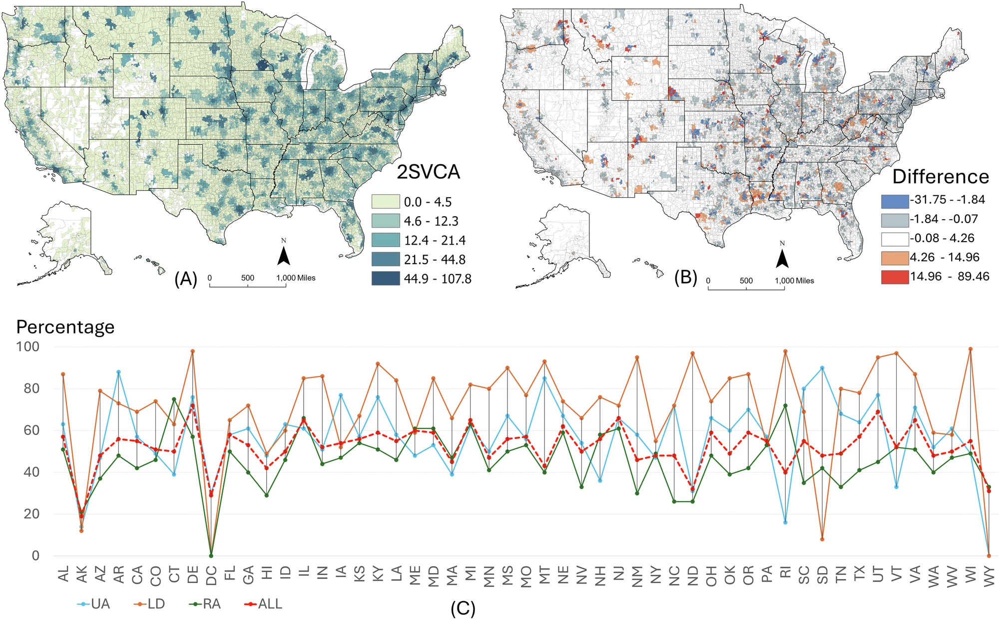
Using 2SFCA and 2SVCA models across 33,499 ZIP Code Tabulation Areas in the United States, this study evaluates in-person and telehealth accessibility for cancer care by integrating physician locations, cancer incidence, travel-time networks, and broadband coverage/subscription indicators. Accessibility declines from urban to rural areas and in more socioeconomically deprived communities. Telehealth helps reduce disparities but does not eliminate them, and interaction effects among rurality, deprivation, and racial/ethnic composition reveal compounded structural disadvantages.
Reconciling 2SFCA and i2SFCA via distance decay parameterization
International Journal of Geographical Information Science, 2025
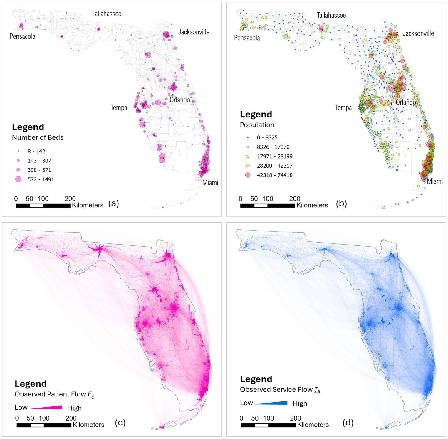
This paper proposes a distance-decay parameterization framework to reconcile demand-side accessibility (2SFCA) and supply-side crowdedness (i2SFCA) through a unified, entropy-based optimization strategy. By minimizing cross-entropy between estimated flows, the reconciled 2SFCA (r2SFCA) model aligns accessibility and crowdedness under a behavioral equilibrium interpretation. A Florida inpatient hospital-flow case study shows strong agreement between estimated and observed flows while preserving model simplicity for practical planning applications.
Cancer Incidence Data at the ZCTA Level in the U.S. Interpolated by Multi-Constraint Monte Carlo Simulation
Scientific Data, 2025
High-quality cancer data are fundamental for public health research and policy, but cancer data for small geographic units and population subgroups in the United States are rarely available due to small-sample suppression rules, spatial coarsening, and data incompleteness. These limitations hinder high-resolution spatial analyses and precision public health interventions. This study provides a high-resolution cancer incidence dataset for the U.S., generated through a multi-constraint Monte Carlo simulation framework that reconstructs suppressed county-level cancer data and systematically disaggregates them to ZIP Code Tabulation Areas (ZCTAs), guided by demographic constraints. This method integrates population subgroup structures and macro-level incidence rates as constraints, ensuring consistency and reliability across spatial scales. The resulting dataset spans multiple geographic units, from state and county levels to ZCTAs, enabling comprehensive analyses of cancer burden, in-depth spatial analyses, and precision public health interventions across multiple scales..
Delineating urban agglomeration regions in China by network community scanning: Structures and policy implications
Cities, 2025
This study employs the network community scanning (NCS) method to analyze inter-city human flow network patterns using the most recent 2023 Baidu mobility data in China. Specifically, it uses the Community Multiresolution Overlap Scan (CMOS) technique to define regions comparable to the recently government designated urban agglomerations (UAs) and other administrative units (i.e., economic regions and provincial units) so that the delineated and targeted regions overlap most. The results reveal a larger spatial context for multiple UAs to interact as well as a centric structure to detect within each UA. By comparing designated UAs and the NCS-derived comparable regions, it largely validates the rationale of UAs. More in-depth examination reveals discrepancies on a finer scale. Based on community affiliation index (CAI) and PageRank centrality, the centric structure analysis of designated UAs identifies whether an UA is absent of any central city, led by a dominant center, or jointly anchored by multiple centers. The efficient network delineation algorithm supported by timely mining of big data enables policy makers to examine the hierarchical structure of cities in real time and make necessary adjustments.
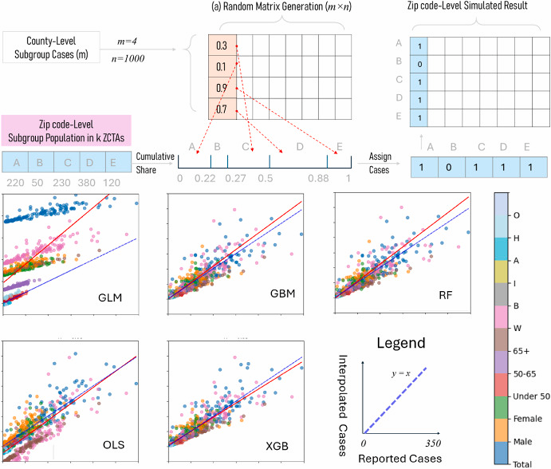
A multi-constraint Monte Carlo Simulation approach to downscaling cancer data
Health & Place, 2025
This study employs an innovative multi-constraint Monte Carlo simulation method to estimate suppressed county-level cancer counts for population subgroups and extend the downscaling from county to ZIP Code Tabulation Areas (ZCTA) in the U.S. Given the known cancer counts at a higher geographic level and larger demographic groups at the same geographic level as constraints, this method uses the population structure as probability in the Monte Carlo simulation process to estimate suppressed data entries. It not only ensures consistency across various data levels but also accounts for demographic structure that drives varying cancer risks. The 2016–2020 cancer incidence data from the Utah Cancer Registry is used to validate our approach. The method yields results with high precision and consistency across the full urban-rural continuum, and significantly outperforms several machine-learning models such as Random Forest and Extreme Gradient Boosting.
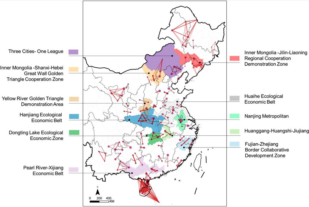
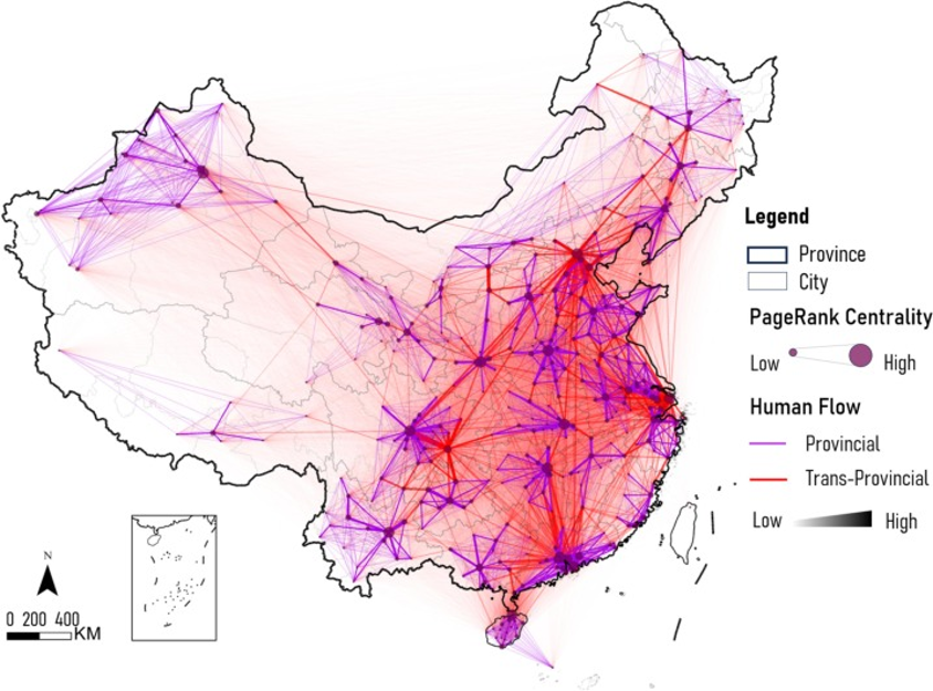
Detect cross-boundary regional collaboration in China using network community scanning and human mobility data
Environment and Planning B: Urban Analytics and City Science, 2025
Accurately identifying and analyzing cross-boundary regional cooperation remains challenging due to administrative constraints and data limitations. This study utilizes high-resolution human mobility data, network community scanning (NCS), and association rule mining to examine trans-provincial cooperation across 369 Chinese cities, leveraging Location-Based Services (LBS) data from 1.3 billion users. The findings indicate that border-adjacent cooperation dominates trans-provincial interactions in China, while non-adjacent cooperation is embedded within broader cooperative networks formed through adjacent ties reinforcing the interwoven nature of cross-administrative collaborations. Additionally, emerging cooperative clusters extend beyond officially designated urban agglomerations, revealing unrecognized regional synergies not yet captured in planning frameworks. These results highlight discrepancies between actual collaboration linkages and government-defined regional plans, underscoring the need for adaptive, data-driven policymaking and offering practical insights for regional planning and governance.
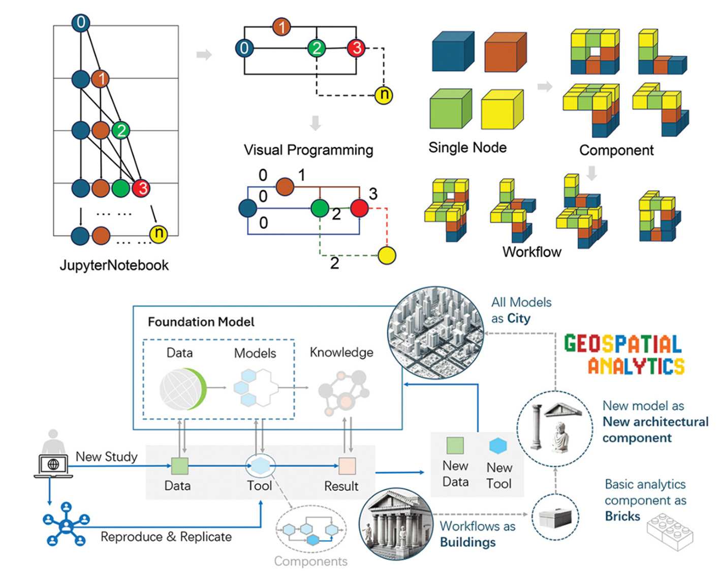
Visual programming-based Geospatial Cyberinfrastructure for open-source GIS education 3.0
Cartography and Geographic Information Science, 2025
Accurately identifying and analyzing cross-boundary regional cooperation remains challenging due to administrative constraints and data limitations. This study utilizes high-resolution human mobility data, network community scanning (NCS), and association rule mining to examine trans-provincial cooperation across 369 Chinese cities, leveraging Location-Based Services (LBS) data from 1.3 billion users. The findings indicate that border-adjacent cooperation dominates trans-provincial interactions in China, while non-adjacent cooperation is embedded within broader cooperative networks formed through adjacent ties reinforcing the interwoven nature of cross-administrative collaborations. Additionally, emerging cooperative clusters extend beyond officially designated urban agglomerations, revealing unrecognized regional synergies not yet captured in planning frameworks. These results highlight discrepancies between actual collaboration linkages and government-defined regional plans, underscoring the need for adaptive, data-driven policymaking and offering practical insights for regional planning and governance.
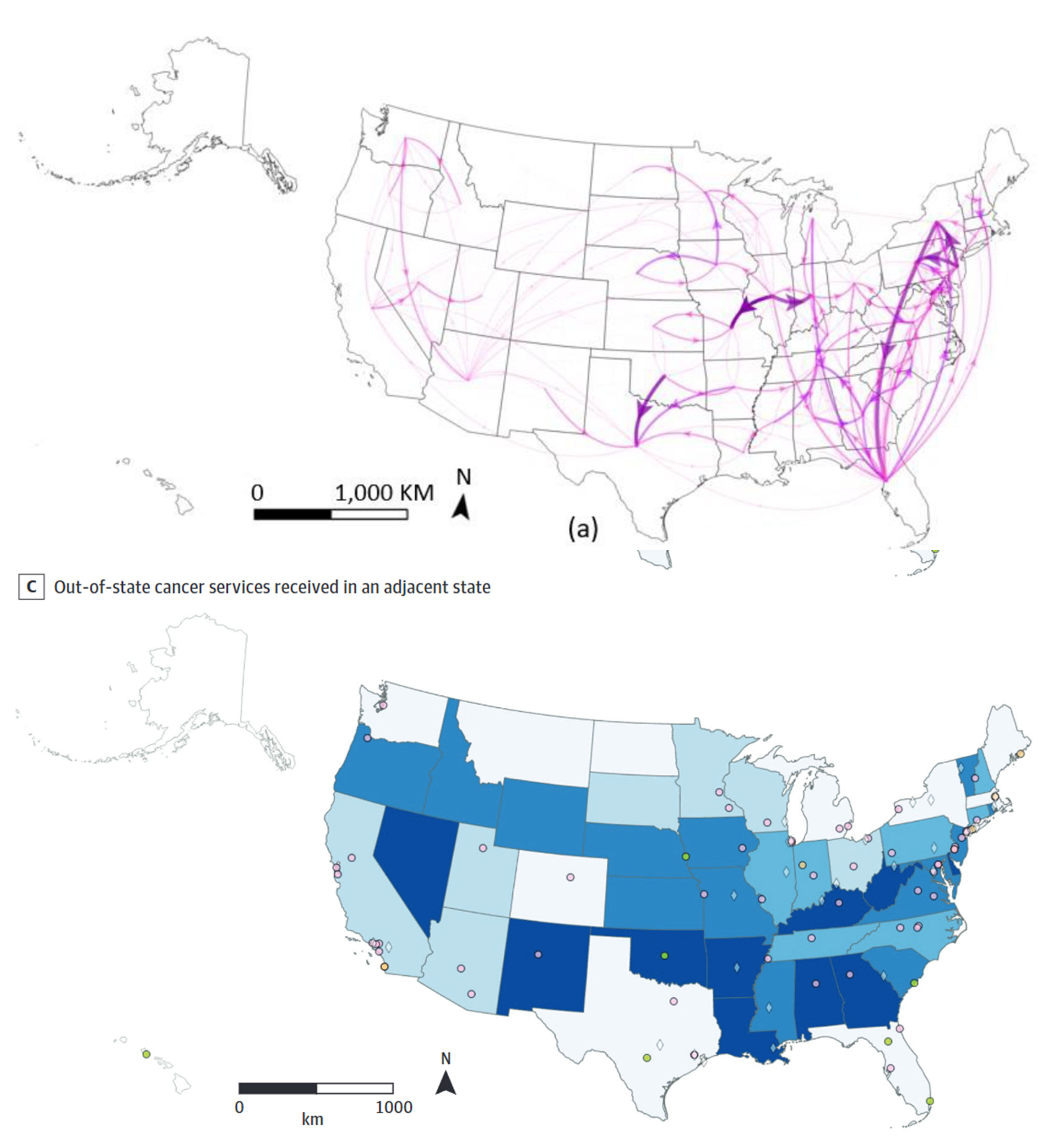
Cross-State Travel for Cancer Care and Implications for Telehealth Reciprocity
JAMA Network Open, 2025
This cross-sectional study analyzed fee-for-service Medicare claims data for beneficiaries (aged ≥66 years) with a diagnosis of breast, colon, lung, or pancreatic cancer between January 1, 2017, and December 31, 2020. Analyses were performed between January 1 and July 30, 2024. The primary outcome of interest was receipt of cancer care across state lines. Frequencies of cancer services (surgery, radiation, and chemotherapy) were summarized by cancer type in relation to in-state vs out-of-state receipt of care based on state of residence for Medicare beneficiaries. Cross-state delivery of cancer services was also quantified by adjacent vs nonadjacent states and overall between-state flows for service utilization.The study included 1 040 874 Medicare beneficiaries with cancer. The mean (SD) age of the study population was 76.5 (7.4) years. Most patients were female (68.2%) and urban residing (78.5%); one-quarter (25.9%) were aged between 70 and 74 years. In terms of race and ethnicity, 7.0% of patients identified as Black, 3.4% as Hispanic, and 85.5% as White. Overall, approximately 6.9% of cancer care was delivered across state lines, with the highest proportion (8.3%) occurring for surgical care, followed by radiation (6.7%) and chemotherapy (5.6%) services. Out of all cross-state care, 68.4% occurred in adjacent states. Frequency of cross-state cancer care increased with patient rurality. Compared with urban-residing patients, isolated rural-residing patients were 2.5 times more likely to cross state lines for surgical procedures (18.5% vs 7.5%), 3 times more likely to cross state lines for radiation therapy services (16.9% vs 5.7%), and almost 4 times more likely to cross state lines for chemotherapy services (16.3% vs 4.2%). In this cross-sectional study of Medicare claims data, a notable proportion of cancer services occurred across state lines, particularly for rural-residing patients. These results highlight the need for cross-state telehealth policies that recognize the prevalence of care delivery from geographically distant specialized oncology services..
Books&Chapters
Computational Methods and GIS Applications in Social Science, 3 Edition
CRC Press, Boca Raton, 2023
This textbook integrates GIS, spatial analysis, and computational methods for solving real-world problems in various policy-relevant social science applications. Thoroughly updated, the third edition showcases the best practices of computational spatial social science and includes numerous case studies with step-by-step instructions in ArcGIS Pro and open-source platform KNIME. Readers sharpen their GIS skills by applying GIS techniques in detecting crime hotspots, measuring accessibility of primary care physicians, forecasting the impact of hospital closures on local community, or siting the best locations for business.
FEATURES: (1) Fully updated using the latest version of ArcGls Pro and open-source platform KNIME;(2) Features two brand-new chapters on agent-based modeling and big data analytics;(3) Provides newly automated tools for regionalization, functional region delineation,accessibility measures, planning for maximum equality in accessibility, and agent-basedcrime simulation;(4) Includes many compelling examples and real-world case studies related to socialscience, urban planning, and public policy;(5) Provides a website for downloading data and programs for implementing all case studies included in the book and the KNlME lab manual
Computational Methods and GIS Applications in Social Science- Lab Manual
CRC Press, Boca Raton, 2023
This lab manual is a companion to the third edition of the textbook computational Methods and GisApplications in social science. lt uses the open-source platform KNlME to illustrate a step-by-step implementation of each case study in the book, KNlME is a workflow-based platform supporting visual programming and multiple scripting language such as R, Python, and java. The intuitive, structural workflow not only helps students better understand the methodology of each case study in the book, but also enables them to easily replicate, transplant and expand the workflow for further exploration with new data or models. This lab manual could also be used as a GlS automation reference for advanced users in spatial analysis.
FEATURES: (1) The first hands-on, open-source KNlME lab manual written in tutorial style and focusedon GlS applications in social science;(2) Includes 22 case studies from the United states and China that parallel the methodsdeveloped in the textbook;(3) Provides clear step-by-step explanations on how to use the open-source platformKNlME to understand basic and advanced analytical methods through real-life case studies;(4) Enables readers to easily replicate and expand their work with new data and models;(5)A valuable guide for students and practitioners worldwide engaged in efforts to developGlS automation in spatial analysis