2025-06-01 — New Paper Published: "Digital Divides in Telehealth Accessibility" in npj Digital Medicine. Learn more →
2025-05-10 — Dataset on ZCTA-level cancer incidence interpolation released on Harvard Dataverse. Learn more →

2025-06-01 — New Paper Published: "Digital Divides in Telehealth Accessibility" in npj Digital Medicine. Learn more →
2025-05-10 — Dataset on ZCTA-level cancer incidence interpolation released on Harvard Dataverse. Learn more →
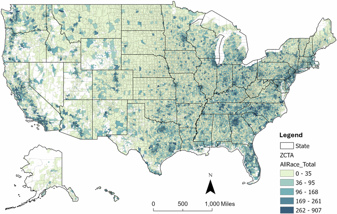
This project develops a high-resolution, multi-scale cancer dataset in the U.S. by using a multi-constraint Monte Carlo simulation method to estimate suppressed county-level cancer data and further downscale them to ZIP Code Tabulation Areas (ZCTAs). This method integrates population subgroup structures and macro-level incidence rates as constraints, ensuring consistency and reliability across spatial scales. The resulting dataset spans multiple geographic units, from state and county levels to ZCTAs, enabling comprehensive analyses of cancer burden, facilitating in-depth spatial analyses, and designing precision public health interventions across multiple scales.
https://doi.org/10.7910/DVN/W3S2LW
Cancer Incidence Data at the ZCTA Level in the U.S. Interpolated by Multi-Constraint Monte Carlo Simulation,Scientific Data, 2025. https://doi.org/10.1038/s41597-025-05254-8
A multi-constraint Monte Carlo Simulation approach to downscaling cancer data Health & Place, 2025. https://doi.org/10.1016/j.healthplace.2024.103411
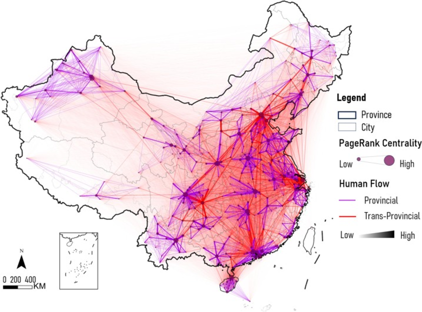
The database contains shapefiles and official policy documents relevant to Chinese Urban Agglomerations (中国城市群), also known as Megaregions. Its base map, in shapefile format, integrates a diverse array of 369 cities and counties, as implemented in Baidu Map. This expansive collection encompasses spatial administrative boundary data and a variety of official Chinese policy documents issued over different periods. It is an invaluable tool for those seeking to comprehend the development and present dynamics of Chinese Urban Agglomerations. Furthermore, the database includes formal plans related to secondary cross-regional cooperation, shedding light on the joint efforts and strategic plans among different areas. This extensive dataset is crucial for researchers, policymakers, and anyone interested in the progression and management of urban clusters in China.
https://doi.org/10.7910/DVN/INBNQO
Delineating urban agglomeration regions in China by network community scanning: Structures and policy implications,Cities, 2025 https://doi.org/10.1016/j.cities.2025.105721
Detect cross-boundary regional collaboration in China using network community scanning and human mobility data,Environment and Planning B: Urban Analytics and City Science, 2025 https://doi.org/10.1177/23998083251339482
This textbook integrates GIS, spatial analysis, and computational methods for solving real-world problems in various policy-relevant social science applications. Thoroughly updated, the third edition showcases the best practices of computational spatial social science and includes numerous case studies with step-by-step instructions in ArcGIS Pro and open-source platform KNIME. Readers sharpen their GIS skills by applying GIS techniques in detecting crime hotspots, measuring accessibility of primary care physicians, forecasting the impact of hospital closures on local community, or siting the best locations for business.
https://doi.org/10.7910/DVN/4CM7V4
Computational Methods and GIS Applications in Social Science, 3 Edition,CRC Press, Boca Raton, 2023 https://doi.org/10.1201/9781003292302
Computational Methods and GIS Applications in Social Science- Lab Manual,3 Edition,CRC Press, Boca Raton, 2023 https://doi.org/10.1201/9781003304357